
by Ms. S. Swathi Meenakshi*
_______________________
_______________________
He
who holds Tibet dominates the Himalayan piedmont; he who dominates the
Himalayan piedmont threatens the Indian subcontinent and he who threatens the
Indian subcontinent may well have all of South Asia within his reach, and with
it all of Asia.
~
George Ginsburgs and Michael Mathos[i]
Relations between India and China have traditionally
been tenuous. Earlier, the mountainous terrain of the Himalayan ranges, Tibet,
Bhutan and Nepal acted as buffer areas to ease tension between the two Asian
giants. But, recent infrastructure developments along the border raise
questions of concern. China’s build up holds important security implications
for India and adds heat to age old territorial claims. Given this background,
of particular significance is the construction of the Qinghai-Tibet Railway
line. This railroad symbolizes China’s sovereignty over Tibet while
establishing its technological prowess in building the highest railroad in the
world[ii].
The railroad will gain ever more strategic significance as it connects hitherto
inaccessible parts of the Tibetan plateau with the ‘Chinese motherland’. This
paper tries to examine the geopolitical[iii]
implications of such developments.
Engineering Marvel
The Qinghai-Tibet railroad runs a total length of
1,956 kms[iv]
and involved the construction of 286 new bridges and 30 kilometres of tunnels[v].
At 5,072 metres above sea level, the Tanggula railway station in the Kunlun
mountain range is the highest operated station monitored by satellite. Dubbed
as a ‘great miracle of the world’s railroad history’[vi],
this railroad has seemingly solved the three problems of frozen tundra, high
altitude and plateau environmental protection[vii] through
various technology interventions. For instance, about 632 kms of the line runs
through permafrost of which 100 kms have been declared as highly unstable[viii].
To prevent melting and freezing due to day time temperature changes and
seasonal variations, for every four yards two thermosiphons (ammonia filled
cooling pipes that dissipate heat) have been inserted at a depth of 300 feet.
 |
| The vertical sectional diagram of the Qinghai-Tibet Railway (Golmud-Lhasa section) Source: ChinaTravelGuide.com |
Early Connections
The plans for the first roads in the Tibetan plateau
were laid in China’s First Five Year Plan (1953-1957) that allocated $4.23
billion on ‘transportation and communications’[ix].
The highway construction that began then has continued till date with five
major highways being built[x].
Each of these highways was driven by “a political passion for road building”[xi]
and have served in strategic and military capacities as well. According to Jan
S. Prybyla[xii],
the Sichuan-Tibet and the Qinghai-Tibet highways were constructed with the
specific purpose of facilitating ease of invasion of Tibet. It is also
speculated that the Xinjiang extension of the Sichuan-Tibet highway may have
been one of the causes of Sino-Indian conflict[xiii].
Name
of Highway
|
Starts
at
|
Ends
at
|
Length
(in kms)
|
Year
of completion
|
Sichuan-Tibet
Highway (highest highway in the world)
|
Chengdu
|
Lhasa
(runs through 14 mountain ranges and 12 rivers)
|
2413
|
1954
|
Qinghai-Tibet
Highway
|
Xining
|
Lhasa
(runs through Amdo, Gharmo and Nagchuka )
|
1965
|
1955
|
Xinjiang-Tibet
Highway[xiv]
(extension to Sichuan-Tibet highway)
|
Lhasa
|
Yarkand
(runs through Shigatse, Sakya,
Lhatse
and Rutok)
|
1210
|
1957
|
Yunnan-Tibet
Highway
|
Hsiakuan
(Xiaguan)
|
Mangkam
in Tibet and then merges with Sichuan-Tibet highway
|
315
|
1976
|
China-Nepal
Highway (Golden passageway)
|
Shigatse
|
Passes
through Lhatse, Tingri and Nyalam before reaching
the
Friendship Bridge in Dram continuing upto Kathmandu
|
736
|
1965
|
Table
1[xv]:
Major highways connecting the Tibetan Plateau and China
Table 1 above shows how well planned the road building activities were so as to connect major Tibetan cities in the East and West with China and the border areas up to Nepal.
‘Go West’
In its 12th Five Year Plan (2011-2015), China began
its ambitious Great Western Development Strategy to “redirect large amounts of
central government spending, foreign direct investment, and international
economic development funding to the western regions”[xvi].
The call for a railroad was made by Dr. Sun Yatsen in his ‘blueprint for Tibet’[xvii].
These plans saw a revival in late 1950s with the completion of the first line
linking Tibet and China – between Lanzhou and Siling. In July 2006, when the
Qinghai-Tibet railroad was completed a year ahead of schedule, it had shot its
initial budget by 50% thus totaling $4.2 billion[xviii].
However, several years before the commencement of construction, former
President Jiang Zemin opined that construction of the railway line “is a
political decision, we will make this project succeed at all costs, even if
there is a commercial loss”[xix].
This statement is indicative of the Chinese interest in the railroad.
One railroad, Multiple Purposes
The Qinghai Tibet railway has carried 49 million
passengers since opening in 2006[xx].
In present day Tibet, there are six million Tibetans and ten million Han
Chinese[xxi].
The construction of the railroad signified demographic changes similar to the
case of Mongolia, Manchuria and East Turkestan before Tibet. Tourism industry
has seen a 30% increase since the construction of the railroad with 93% of the
tourists being Chinese[xxii].
Mines and industries have mushroomed in the area[xxiii].
While the World War II period saw Chinese nationalists asserting superiority
through suzerainty over border regions, present day Chinese nationalism has
added a newer colour. Resource nationalism and ‘arms for oil’ policy has seen
the proliferation of weapons and construction of military bases to secure
energy resources. According to a 2005 report by Booz-Allen-Hamilton, China’s
emerging maritime strategy at the time was called ‘string of pearls’[xxiv]
where each pearl is a nexus of Chinese geopolitical or military presence. China
has now set its eyes on strengthening its People’s Liberation Army Air Force
(PLAAF). China has now set its eyes on strengthening its Air Force as seen from
the military exercises it has conducted since the construction of the railroad.
Additionally, the rivers that originate from here serve as a source of water
for the growing Chinese population and for the drier Chinese regions. In fact,
a dam has been proposed across the Great Bend of the Brahmaputra river.[xxv]
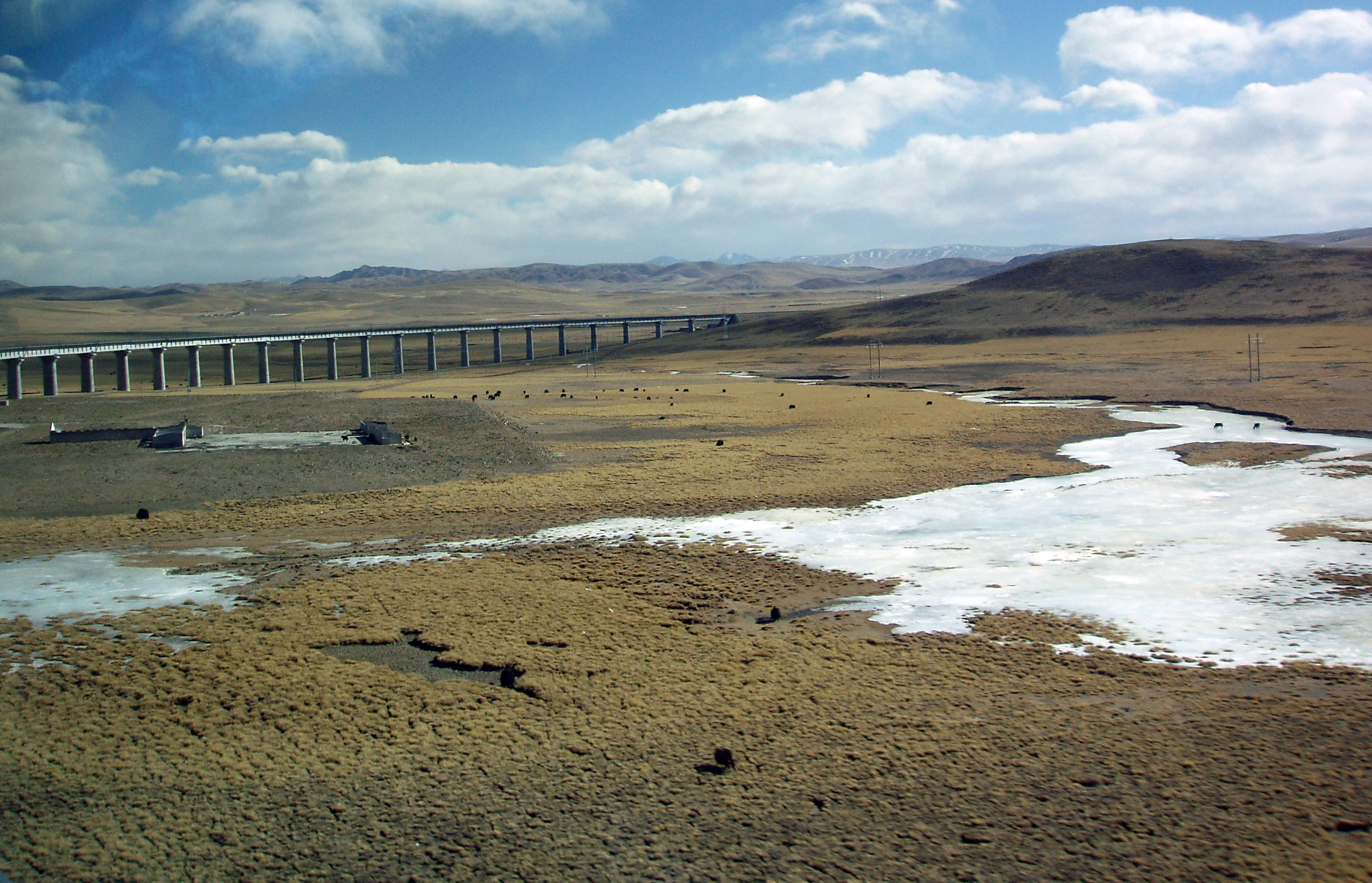 |
| A bridge on permafrost Horizon. The Gormo-Lhasa Railway line runs through some of the most sensitive permafrost region of the Tibetan Plateau. Image courtesy: Fanghong/Wikipedia |
Strategic Advantage
According to the Global Militarisation Index
produced by the Bonn International Center for Conversion, China recorded a
whopping 216% increase in military budget between 2000 and 2009 as against 67%
by India[xxvi].
The construction of infrastructure forms a major part of this budget. The strategic
and military potential of the Qinghai Tibet railroad was first established in
March, 2008 when the PLA moved its troops within 48 hours to quell the protests
in Lhasa. The T-90/89 armored personnel carriers and T-92 wheeled infantry
fighting vehicles carried officers in “leopard” camouflage uniforms
specifically used in mountain warfare operations as the 149th Division of the
No. 13 Group Army under the Chengdu Military Region was dispatched to Lhasa[xxvii].
Besides, the PLA is involved actively in the design and planning of the
high-speed railroads[xxviii].
For example, Chengdu Railway Bureau has 14 military officers holding critical
posts in key departments at all major stations, are assigned tasks starting
from design and planning to implementation. The Military Transportation
Department of the PLA General Logistics Department (GLD) has equipped over 1000
railway stations with military transportation facilities, which according to
Christina Lin establishes a complete railway support network that enhances the
PLA’s strategic projection capability[xxix].
Several military exercises have been undertaken by
the PLA since the construction of the line. These reached a pinnacle in 2010
when China formulated “Mission Action 2010” aimed at conducting joint military
exercises between the seven military regions. A summary of these activities is
given below[xxx].
The PLA transported “important combat readiness material” via the Qinghai-Tibet
railroad later identified as ballistic missiles in order to test them under the
rarefied atmospheric conditions of the Tibetan Plateau. In October, 2010, PLA
conducted a live military training exercise in order to acclimatize its troops
to the problems of high altitude – low oxygen content, altitude sickness and
other related health problems. These exercises were a follow-up to the 2009
exercise code named ‘Stride’ which saw similar inter-regional participation.
Since the construction of the railroad, China has often tested the capacity and
readiness of the line whose assessed capacity is eight trains per day (one way)
and 3200 tonnes per train[xxxi].
Recently, on March 20, 2012, PLA Daily reported an information-based drill
conducted by the air force of Chengdu Military Area Command (MAC). According to
the report, the drill focused on “striking simulated targets with diverse
properties in light of actual combat”. Furthermore, such exercises in recent
years “ascertain the fully-functional usage rule and strike effectiveness of
weaponry and equipment in a high-altitude and complex environment and effectively
enhancing the all-weather and around-the-clock combat capability of its troop
units in all territories”[xxxii].
In each of these exercises, the troops and logistical support has often been
provided through the railroad. Unconfirmed reports also suggest plans for
construction of a second line devoted to freight transport.
Nuclear Weapons build-up
The first nuclear weapon was brought into the
Tibetan Plateau in 1971 and installed in Tsaidam basin in Amdo[xxxiii].
As early as 1995, Xinhua reported the possibility of a nuclear pollution due to
dumping of radioactive pollutants near Lake Kooknoor, the largest salt water
lake in Tibet. A nuclear facility, popularly known as the “Ninth Academy” was
established to carry out nuclear weapons building and research[xxxiv].
(The facility is now decommissioned and has been converted into a museum). A
2005 book by renowned defence expert Saran Singh reveals, “A nuclear missile
(DF-4 ICBM) launch site is also located at Terlingkha (217 km southeast of
Tsaidam)” and the construction of 14 airbases. Going by this trend, it seems
only logical to extrapolate the proliferation of such arms and construction of
further facilities given the development of roads and railway lines in recent
years.
In 2008, according to Hans Kristensen, the director
of the nuclear information project of the Federation of American Scientists: “Analysis of new commercial satellite
photos has identified an extensive deployment area with nearly 60 launch pads
for medium-range nuclear ballistic missiles in Central China”. In a
presentation by Vincent Matten of the International Campaign for Tibet on
February 29th, 2012, there are 4 nuclear missile launch sites are located in
the Qinghai Province today[xxxv].
There are also issues of radioactive poisoning of at least 50 Tibetans in the
north-western region of Gansu province. This region is reported to have the
largest deposits of uranium in the world (according to Communist Party
Official, Yin Fatang) and indiscriminate mining has already commenced[xxxvi].
Communication infrastructure
Chinese build-up along the border includes roads and
railway networks, support infrastructure such as communication, securing oil,
gas and other energy resources and dams, power projects and grids[xxxvii].
This section focuses on the communication infrastructure which is viewed as a
sort of surveillance network rather than a means of connecting. With a view to
enhance the ease of communication along the railroad, heavy investments have
been made in collaboration with Nortel Networks of Canada. Railway
communication systems technology, as provided by Nortel are part of China’s Golden Shield Project, an all-seeing network
that links national, regional and local security agencies, thereby improving
the state’s efficiency in monitoring and controlling the flow of information
and people[xxxviii].There
is wide speculation that the communication towers that are springing up every
6.7 kms along the railroad will form vital nodes of a tactical communication
network (using C4I technologies - command, control, communication, computers and
intelligence) for the PLA[xxxix].
Future plans and extensions
Extension of the railway line to Shigatse is due to
be completed in 2015[xl].
Several other extensions have also been planned in the aftermath of the April
2010 Kyrgyzstan crisis that led to the collapse of the local government. A
“Grand Peripheral Strategy” was charted by Chen Xiangyang, an associate
researcher at the Chinese Institute of Contemporary International Relations
(CICIR), to safeguard China’s neighboring areas that resonated among the senior
Chinese leaders[xli].
In addition to the railway lines in Tibet, China is building railroads to Nepal
and is planning high-speed rails to Laos, Singapore, Cambodia, Vietnam,
Thailand and Myanmar[xlii].
In addition, on November 15, 2010, Iran, Afghanistan and Tajikistan have agreed
to cooperate with China in building a China-Iran railroad starting from
Xinjiang. A possible long term ambition would be to connect to Iraq (where
China has heavy oil and gas investments), Syria, and Turkey and even up to
Europe.
Recommendations and Conclusions
Recent developments across the Chinese border have
important ramifications for India. The issue of Arunachal Pradesh is a
constantly simmering one where India has traditionally adopted a “war of
attrition[xliii]”
approach. With the build-up of roads, railway networks, nuclear facilities,
rapid action forces, this age old approach is hardly going to hold. The Indian
government seems to be waking up to this reality and responding with a sense of
late urgency. The Home Ministry has sanctioned “Rs.1,934 crore on 4th
June 2012 for strategic road projects of about 804 kms in order to support the
operational movement of the Indo-Tibetan Border Police (ITBP) along the
India-China border, both in the eastern and the western sector. This includes
the territory from the Karakoram Pass in Ladakh to Jachep La in Arunachal
Pradesh covering about 3,488 kms of border. The task of building these roads
have been given to the Border Roads Organisation (BRO), the Central Public
Works Department (CPWD), and the National Projects Construction Corporation”[xliv].
In light of the current dynamics across the border,
a neutral Tibetan plateau becomes essential in restoring balance in Asia. In
the words of Sadar Patel, “(Throughout
history) the Himalayas have been regarded as an impenetrable barrier for any
threat from the North. We had a friendly Tibet which gave us no
trouble….Chinese ambitions in this respect not only cover the Himalayan slopes
on our side, but also include the important part of Assam… Chinese irredentism
and communist imperialism are different from the expansionism or imperialism of
the western powers, which makes it 10 times more dangerous. In the guise of
ideological expansion lie concealed racial, national and historical claims”.
While securing Indian borders by ramping up infrastructure is essential, a long
term solution will only arise when the issue of Tibet is swiftly advanced in
the international arena with the intention of resolving it.
[i] George Ginsburgs
and Michael Mathos, Communist China and Tibet: the First Dozen Years, Hague:
Martinus Nijhoff, 1964, p. 210
[ii] gov.cn
– ‘Facts about Qinghai-Tibet railway’, Chinese government’s official web portal
- http://english.gov.cn/special/2005-10/15/content_308490.htm
[iii] Geopolitical
analysis here ascribes to Geoffrey Parker’s definition which is to analyze the
background of the international situation from a spatial or geographical
perspective
[iv] ‘Journey
to the roof of the world’, China Daily, Jan. 22, 2007. Available at: http://www.chinadaily.com.cn/cndy/2007-01/22/content_788568.htm
[v] “Tibet
Railway to Fast-track Economic Goals”, World Tibet Network News, 23 July 2001, http://www.tibet.ca/en/wtnarchive/2001/7/22_1.html
[vi] In
an epic keynote speech made by the Chinese President Hu Jintao on July 1, 2006,
the railroad was dubbed a miracle asserting China’s stance as a technological superpower. The President
addressed an audience of 2,600 people in front of the Gormo railway station
[vii] ‘Qinghai-Tibet
rail rumbles across roof of the world’, China Daily, Jul. 1, 2007. Available
at: http://www.chinadaily.com.cn/china/2006-07/01/content_630898.htm
[viii] “China’s
train, Tibet’s tragedy’, p. 52. EDD Publication
[ix] Feng-hwa
Mah, “The First Five Year Plan and Its International Aspects”, in C. F. Remer
(ed.), Three Essays on International Economics of Communist China, Ann Arbor:
University of Michigan Press, 1959, p. 49
[x] Sino-Tibetan
Relations 1990-2000: Internationalization of the Tibetan Issue, Dolkar, Tsetan,
February, 29, 2008, p. 232
[xi] Ibid,
p.234
[xii] Jan
S. Prybyla, “Transportation in Communist China”, Land Economics, vol. 42, no.
3, August 1966, p. 273
[xiii] Ibid,
p. 274
[xv] All
figures provided, otherwise mentioned are drawn from “Sino-Tibetan
Relations 1990-2000: Internationalization of the Tibetan Issue”, Dolkar,
Tsetan, February, 29, 2008
[xvi] Wikileaks
Documents Release, “Tibet: Problems, Prospects and US Policy”. Available at: http://wlstorage.net/file/crs/RL34445.pdf
[xvii] Dr.
Sun Yatsen’s vision for development of Tibet is available at: http://chinatibet.people.com.cn/6660092.html
[xviii] “The economics
of the Gormo-Lhasa railroad”, China’s Train, Tibet’s Tragedy, EDD Publication,
2009, p. 66
[xix] Jiang
Zemin, New York Times, August 10, 2001. Available at: http://www.nytimes.com/2001/08/09/international/asia/10CTEXT.html?p.wanted=all
[xxiv] The phrase
“string of pearls” was first used to describe China’s emerging maritime
strategy in a report titled “Energy Futures in Asia” by defense contractor,
Booz-Allen-Hamilton, which was commissioned in 2005 by the U.S. Department of
Defense’s Office of Net Assessment. Christopher J. Pehrson, String of Pearls
[xxvi] The full text of
the report is available at: http://www.bicc.de/uploads/pdf/publications/papers/occ_paper_07/occasional_paper_VII_02_11_eng.pdf
[xxviii] Xinhua News
Agency, December 7, 2010
[xxx] A detailed
account is available at: http://www.southasiaanalysis.org/%5Cpapers43%5Cpaper4277.html
[xxxiii]
“Demilitarisation of the Tibetan Plateau: An Environmental Necessity”, EDD
Publication, p. 13
[xxxv] French expert on
Tibet, Anne Marie Blondeau
[xxxvii] “Chinese
build-up in Tibet and implications for India”, Presentation by Brig (Retd)
Rahul K Bhonsle
[xxxix] This
communication network takes advantage of existing technology such as GIS, GPS
and GSM-R to come up with a new system. The Geographic Information System (GIS)
is a suite of software and hardware tools designed to combine relational
databases with satellite maps of the earth’s surface. It helps in translating
mapped information along with relevant attributes in a form that is easy to
retrieve and manipulate. For rail transportation applications, spatial data
which graphically represents the geometry of the rail network is visually
cross-referenced with related attributes, for example, the location of bridges,
stations and rolling stock, or socio-economic data to support decision making.
The Global Positioning System (GPS) is a satellite navigation system operated
by the United States Department of Defence. It consists of a constellation of
24 satellites orbiting the earth and six ground stations. The satellites
transmit a signal that allows the user to determine with some accuracy the
precise location of their GPS receiver. GPS receivers are accurate to within
less than 15 metres. GSM-R (Global System for Mobile communication - Railway)
allows wireless communication between trains and control centers. Like GSM,
voice and data transfer is also possible. Also, voice calls, walkie-talkie type
communication, call initiator alone speaks calls and high priority calls for
emergencies are also possible. The G3 system integrates these three
technologies (GIS + GPS + GSM-R) to create a state-of-the-art information planning
system for the railway. Nortel’s GSM-R system provided Beijing Jiaotong
University with all the services it required to successfully deploy the G3
system: remote train control, voice communications for all users, emergency
call handling, data message exchange, communication recording, and integration
capacity with other existing (or future) systems.
[xli] Ta Kung Pao
[Hong Kong], September 24, 2009
[xliii] Attrition
warfare is a technique employed by a side with greater resources to wear down
the opposing side. The belligerent side wins over the other side by causing
enormous loss of life and property. An example is that of World War I when the
Allied Powers wore down the Central Powers to the point of capitulation.
[xliv] IDSA Commentary
by Namrata Goswami, June 7, 2012
__________________________________
* Ms. S. Swathi Meenakshi is presently a volunteer at Environment & Development Desk (CTA) and also a participant of the 12th Gurukul Programme being held in Dharamshala (5 June-7 July 2012). She completed her Bachelors in Electrical & Electronics Engineering from College of Engineering, Guindy, Anna University and will be matriculating into the graduate program in Electrical and Computer Engineering at McGill University, Montreal, Canada in the coming fall.
No comments:
Post a Comment